Day 7 – Winter is on its way

October 21, 2018

Akureyri to Akranes

**We’ve decided to include the date and start/end locations for each day in our posts. We will be going back through our blog in the next dew days and adding this information to each post. If you want us to include any other information please leave a comment.**

Laurie woke up dreaming of toast and butter. Luckily there was a toaster in our hostel and we still had ” bakari” bread (aka bakery but we like saying this because it is one of the only Icelandic words we can pronounce).

The window in our room had ornamental indentations so we couldn’t do our usual morning weather check. The wind was no longer howling but there was a constant hum that we hoped wasn’t rain.

It wasn’t but the sky was still pretty dark. And darker in the direction we were headed.

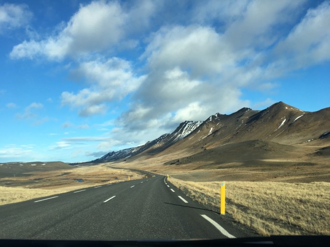
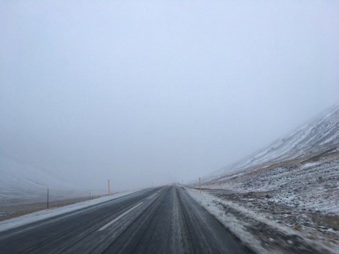
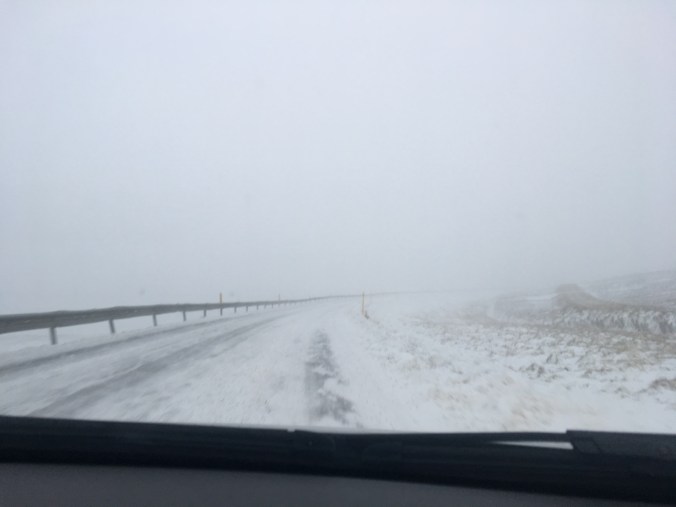
As we drove north and then west of Akureyri it started to rain, then sleet and finally snow. The road began to climb as the winds picked up and soon we were driving through a little blizzard.

With visibility less than 50 feet at times, Andy kept the car in our lane by using the yellow snow posts as a guide. Luckily there were no other cars around so we went as slow as we wanted.

We passed a snow plow and the first Icelandic official vehicle we have seen on our trip. The guy was chilling in his truck on the side of the road – probably with his vehicle running and the heater on.

A few times we wondered if the road was open but figured they would have closed a gate if it wasn’t. So we kept going. Locals would probably laugh at us for considering today’s weather a storm.

As we neared the top, the wind mellowed. Our studded winter tires worked well and we both felt at ease while enjoying the adventure.

As we headed down to the next valley we eventually fell below the snow line and entered into the rain again.

The road continued like this for another 2 “passes.” Even the sheep were dusted white from the snow at the higher elevations.

At one point our car read -1 degree, the coldest it has been thus far (not considering the wind chill). We pulled out our big puffy coats for the first time this trip.

There weren’t many points of interest along the first half of today’s drive. We attempted to locate the waterfall of Reykjafoss. Google maps directed us down a road and we could see a size-able gorge and a river but there was never a spot to pull off or any path (or hole in a fence) to hike through. We eventually gave up and drove back to the main highway (Road 1).

Laurie moved in and out of slumber while Andy drove and enjoyed the scenery.

Eventually the skies cleared a little as we pulled into a parking area containing more cars than we had seen all morning.

We walked up wooden steps to circumnavigate the Grabrok crater which was formed by an eruption approximately 3,000 years ago.

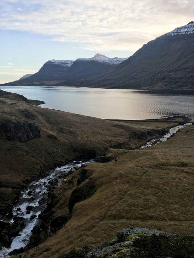
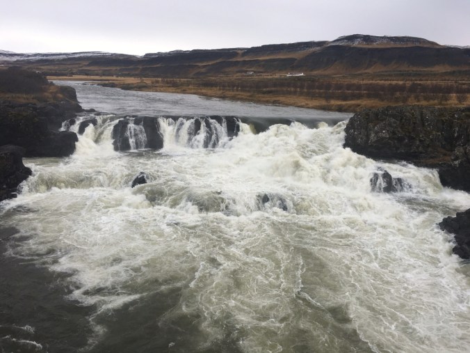
We then drove about 10 minutes to the Glanni waterfall. We were the only people there, which was strange given the popularity of the neighboring Grabrok. We walked the main trail then followed a smaller path (which was quite wet) back the car.

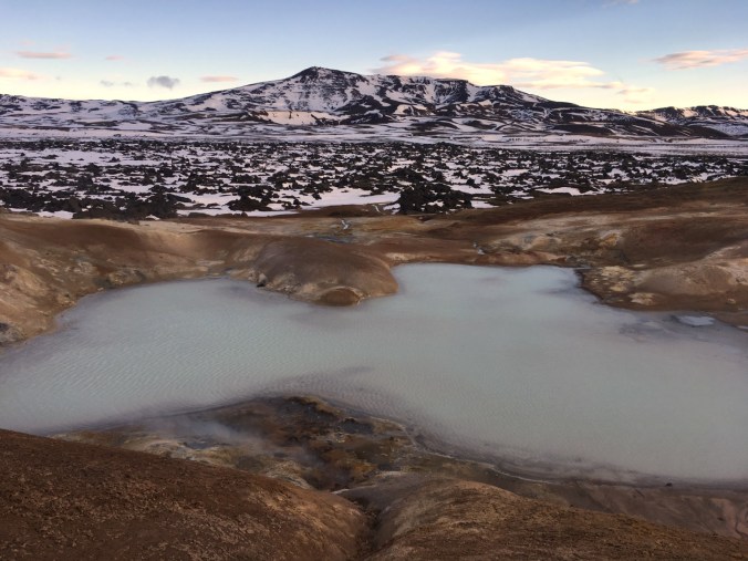
It was another hour from here to the Deildartunguhver hot spring. This is the fastest flowing hot spring in the world. So much hot water comes out of the ground here that through ~70 km of piping it supplies hot water to the surrounding towns! The pipe network reminded us of the pipes that direct water from the Eastern Sierra to Los Angeles.

There was a fancy hot spring there but we decided to indulge in hot chocolate and carrot cake rather than take another hot plunge.

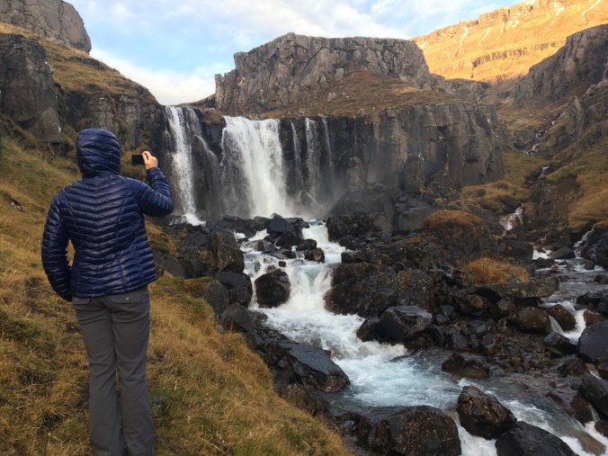
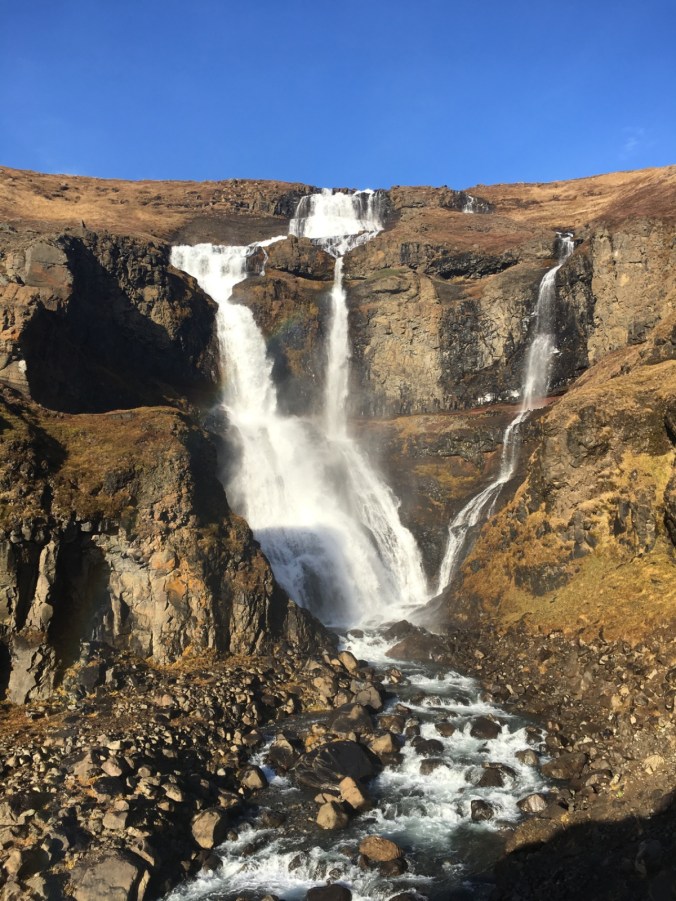
From here we took a little side trip up to Hraunfossar – one of the most unique waterfalls in Iceland. Here water flows out of lava tubes and into a river.

It’s hard to see what’s special about it at first. But then your brain catches up with your eyes and you think to yourself, “wait, where is this water coming from?”

We walked around as much was we could until it started to pour. Laurie ran back to the car as she had opted to wear her warm big puffy jacket which was not water proof.

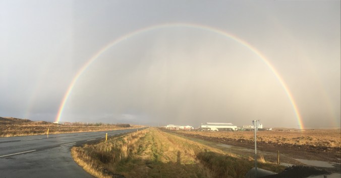
The clouds produced more rain, then hail, then horizontal rain directly into our car enroute to our last stop. Along the way we stopped at a turnout to video chat with Andy’s parents and show them the incredible double rainbow behind us.

As we drove into Akranes – our home for the night, the clouds parted slightly and the sun came out.

This coastal town relies heavily on the fishing industry as its main source of employment.

Once settled in our hostel we decided to take a walk to stretch our legs after 6 hours in the car. We had about an hour of daylight so we wandered toward the lighthouse.

The smell of sea and fish wafted through the air. The wind picked up and eventually it began to hail. We choose our route to avoid long exposed areas.

Eventually the hail subsided as did the rain. We walked for about an hour – winding through small streets and gazing into warmly lit houses.

We returned to our hostel and made dinner consisting of beans, rice, cheese, tomatoes and greens after Laurie took a nice warm shower. It was fun to know where the water was coming from!

Tonight we are grateful for cozy accommodations and winter tires.
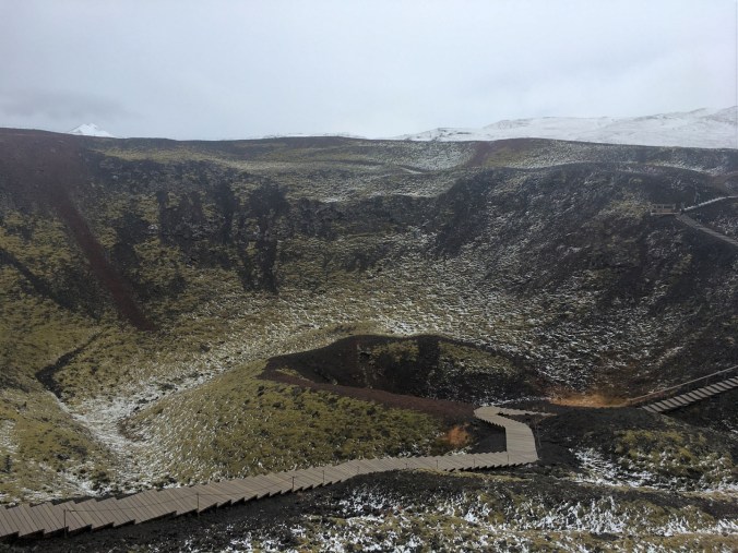
Grabrok Crater

Glanni waterfall

One steo, two step, repeat. And don’t fall in

Deildartunguhver hot springs

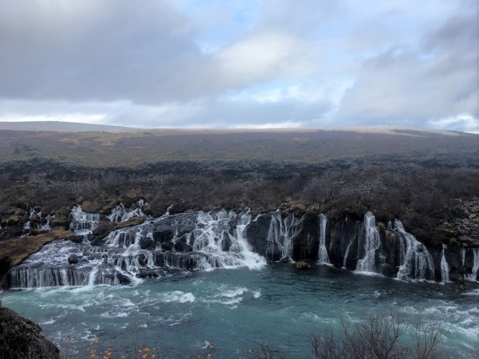
The most unique Hraunfossar waterfalls

Interesting rock formation or massive pile of cow dung?

Laurie tried to put Andy’s rain hood on. It didn’t go well.

Day 5 – Highway To The Thermal Zone

October 19, 2018

Seydisfjordur to Myvatn

In order to see the northern lights one must have all three of the following: solar activity, clear(ish) skies and little light pollution. Last night there was a slight chance (a score 3 out of 9) for solar activity and clear skies. Our hostel was on the outskirts of town.

That was enough for Andy to set his alarm for midnight with hopes to see his first northern light show.

There were a few stars out at midnight so Andy got dressed and headed outside. He looked up and immediately saw a shooting star.

He was happy. It wasn’t too cold and the sky kept clearing. He was hopeful. He called his parents, blogged and saw a few more shooting stars.

Around 1:30am the temperature dropped and the wind picked up, but Andy persisted.

At 1:45am he thought he heard chickens. Fearing he was hallucinating, he thought it was time for bed but he kept hearing them and remembered the hostel offered fresh chicken eggs for 50ISK. Then he heard the ducks calling.

He couldn’t help but laugh.

He returned inside around 2:15am disappointed but content with the multiple shooting stars. Laurie was sound asleep spread across the double bed but easily moved over to let Andy in.

We both had trouble opening our eyes when the alarm went off at 7 am. We bargained with one another and finally got up at 8. We opted to eat on the road to save precious time and daylight. It was going to be another jam packed day.

Our first stop was a waterfall just past the hostel in the opposite direction. The morning air was fresh and only a few clouds hung in the sky. We scampered up the hillside, Laurie aching to just keep hiking.

The constant feeling of needing to keep moving to see it all has been the hardest part of this trip. The weather makes it really hard to plan and there is just too much beauty to see in 10 days.

Essentially this trip feels like a scouting trip so we will know where to come and spend more time next time we come. (And there will be a next time – this country is amazing!!)

We stopped off at Gufufoss waterfall on our way back up the hairpin turns.

On the way down from the pass we noticed a car on the side of the road facing us at an awkward angle. We slowed and stopped to help an older French couple who had veered off the road and buried their wheels in the steep bank.

We were the first of 7 cars to stop and try to help. It was amazing to see how helpful everyone was. Andy and another gentleman attempted to push the car out but the wheels spun and dug deeper into the loose soil.

Ultimately a suave Icelandic driver backed the car down further into the ditch to level it out a bit and gain traction. He then slowly and methodically drove backwards partway up the bank. A big rig positioned itself on the narrow 2 lane road to pull the car out. The locals strapped one end of a tow rope to the car and one to the truck.

As the truck driver slowly inched forward and Mr. Suave slowly drove in reverse, the right rear wheel of the car came off the ground. After a few tense moments all four wheels were on tarmac once again. All the bystanders applauded the efforts of the friendly and helpful locals.

From here it was a long 2 hour stretch through snowy alpine tundra and along a river.

We have been checking the road conditions religiously since we are not in a 4wd car. The road to Dettifoss indicated there were patches of ice but it was fine to drive. We were reassured to see the road was paved all the way to the west side parking lot.

Dettifoss is the largest waterfall in Europe. It is much wider than most and the amount of water that thunders down is insane- according to one guidebook 500 cubic meters (17,700 cubic feet) of water spill over the ledge every second.

The area around the falls is all volcanic and it was fun walking around what felt like a Mars like environment.

Selfoss was a 1 km walk upstream and was a smaller but similarly powerful waterfall. While Dettifoss is a singular and long waterfall at a ~45° angle, Selfoss is more of a bowl shaped waterfall and very pretty in its own right.

Back in the car we drove to Krafla, past a power plant and up to the caldera which was formed during the volcanic activity of the 1970-1980s known as the “Krafla- fires.”

On the way down we saw a bunch of cars and one tour bus parked in a snowy parking lot. Tour buses are our indication of something interesting so we followed the muddy footprints through the snow to the colorful crater of Leirhnjukur.

The sulphur smell was strong but the light blue water and surrounding orange clay provided a nice contrast to the dark molten lava and snow.

We were happy we made the side trip but yet again there was so much to see and it was already 3:30pm. With 2 hours of daylight remaining we opted to skip seeing more geothermal mud pits and instead turned toward the underground hot spring of Grjótagjá.

Unfortunately it is too hot to swim in but to the hands it was nice and the water was incredibly clear. On the way out Andy hit his head on a rock neither of us saw, resulting in a sizeable welt on his forehead (what Armenians call a shishka).

Laurie of course started laughing as Andy asked rubbing his booboo, “Ah, what was that?”

“A rock probably” spit out Laurie amidst giggles.

“Yes, definitely a rock ” confirmed Laurie after lightly hitting her head on the same rock.

Our last stop of the day was the 3,280 foot wide crater of Hverfell. We hurried up the steep path along the side of the crater trying to stay warm. The strong wind whipped sand at our faces near the top.

Once at the top we stayed long enough to take one picture before turning our backs to the wind and heading down.

We checked into our bed and breakfast and went out to eat a nice, tasty farm to table meal.

The restaurant was called Vogafjós Cowshed Cafe. They use the word “cowshed” quite literally as there were cows eating hay right next to the dining room, but that did not stop us from ordering a burger.

We split that and a lamb flank. With so many sheep grazing about we had to try some of the local cuisine.

We are now cozy in bed in our tiny little room with a wall of windows. Fingers crossed for an active evening of northern lights! Today’s score is 4 out of 9 so there may be some green lights overhead..

Tonight we are grateful for sunshine and farm to table restaurants.

Dettifoss

Selfoss (or Selfiefoss if you’re Laurie)

Krafla

Leirhnjukur

Leirhnjukur hot shower (there’s a sink next to it too!)

Grjótagjá hot spring cave

Hverfell crater

Backpacking in Vegas – Day 2

Bushcamp to Trail Canyon Trailhead

Miles: 13.4

Elev gain/loss: +3307 ft/ -5309 ft

We woke up around 6am feeling rested. Knowing it was going to be a long day, the night beforewe had decided to get up early and be walking by 7am.

Like on the PCT, Andy got out of his bag first, retrieved our food and cooked breakfast while Laurie snoozed a few moments longer.

As the sun rose, we savored its warmth while packeding the final pieces of our gear and continued on the switchbacks at 7:30am.

When we reached the saddle we choose to bag Griffith Peak without our packs. We stashed them down the hill, chugged some water and hiked the half mile to the 11,060 ft summit.

Five years ago the Carpenter 1 fire burned a sizeable chunk of the Spring Mountains, including much of the west side of Griffith Peak. Ten years ago when Andy had been there the forest was lush. But the burnt landscape had no effect on his satisfaction for being there with Laurie.

It was windy atop Griffith Peak so after taking a few photos and signing the register we turned around and went for Charleston Peak. We exchanged pleasantries with the only other human who camped on the mountain the night before and continued along the ridge through the burn area.

Andy loved looking toward the west and into Death Valley.  He knew Mount Whitney was out there, in the distance beyond Death Valley but it was not visible in the haze.

We stopped for a snack a few miles from Charleston Peak, then continued along the burn area. The trail runner who had passed us early in the morning was now on his descent. He informed us that the weather to the peak was stellar from here on out. That was good news as the winds can be quite fierce in this range.

After crossing the last of the burn area we were able to see Charleston Peak again. “It looks so far away” Laurie said dejectedly. Andy reassured her that with no switchbacks we were less than 2 miles away. All we had to do was keep truckin’ along.

“Slow and steady.” That is the motto that Laurie’s mom used when taking her hiking as a kid. Whenever at elevation or feeling sluggish that is what repeats in Laurie’s mind.

We came to the site of an old plane crash. Laurie continued on the main trail while Andy took some time to investigate.

Apparently the plane crashed in 1955 with 14 people on board who perished instantly. Andy later described walking around the debris as very eerie. He found it strange that major components of the plane have just been left on the mountain for so long.

We kept chugging along until we reached the top of the 3rd highest peak in Nevada! We felt proud and accomplished. Andy soaked in the views while Laurie took off her pack and took a break inside the man made wind-protected shelter.

It was so well insulated she became too warm and came back out a few moments later. We snacked, took a few photos and briefly chatted with two day hikers who arrived a few minutes after us.

Before noon we shouldered our packs and began our descent to the Trail Canyon Trailhead via the North Loop Trail. Long switchbacks cutting into the mountain above treeline are still one of Andy’s favorite features.

After the switchbacks we found ourselves back into the trees and on a VERY long traverse. The drop offs along the cliffs on the north side of Charleston Peak are so immense that the trail traverses north for 4.5 miles to a saddle where one can continue on the North Loop Trail or down to the town of Mt. Charleston via Trail Canyon Trail.

Laurie lost steam as the trail wound on and on. The views continued to be spectacular and the drop offs in a few spots were downright frightening for Andy, but the heat and the long miles were starting to wear on us both.

We quickly forgot about our tired legs and the heat as we once again crossed through the beautiful orange and yellow quaking aspens. We could see this patch of color from the trail the day before and thought it was beautiful then, but it was so much more magnificent up close.

After walking through the beautiful aspens, we took a shoes-off break at Cave Spring – which still had a steady flow. We snacked, drank more water and continued onward, knowing we were only 2.7 miles from the car.

After a relatively uneventful downhill we reached the trailhead and our car.

Andy really enjoyed sharing this experience with Laurie. These mountains held some special memories for him and he was delighted to have the opportunity to come back here so many years later and experience the beauty of these mountains again – only this time together.

Today we are grateful for ‘healthy’ Pringles and downhills that eventually end.

Griffith Peak (Elev 11,060 ft) and The Strip in the distance

Looking for Telescope Peak in Death Valley

Charleston Peak – Elev 11,916 ft