Day 1 – Mono Pass Trailhead to 1 Mile South of Parker Pass

Wednesday, October 7, 2015

Miles: 6

The three of us left San Francisco at 7:30am and arrived at the Yosemite National Park west entrance around 12:30.

With permits in hand, we drove to Tuolumne Meadows. The tourist season is over in Yosemite. The gear shop and gas station are closed (perhaps permanently) and the Post Office and general store building is being taken down.

Laurie had a great idea to leave our car at the Tuolumne Meadows Wilderness permit office parking lot and hitchhike to the Mono Pass trailhead. This way we’d have a car when we finish our hike. She’s pretty smart!

We snacked/ate lunch as we assembled our bear boxes and were ready to hitch at 2:15pm.

Not having much luck for the first 10 minutes, we decided to make a sign. Five minutes later, Jeff, a climber from Utah stopped to give us a lift in his Subaru.

At 2:45pm, we were on the trail. The fresh air and gently graded trail were a welcoming treat.

We encountered snow as we turned toward Parker Pass. And the views really opened up. The snowy mountains add to beauty of the mountains.

At 5pm, we reached Parker Pass. We descended for maybe a half a mile and set up camp, leaving the very snowy Koip Pass for the next day.

The cold temps descended upon us quickly. After dinner, as the last of the light faded, we retired to our tents around 7:30om.


Pikes Peak – America’s Mountain – By BIke

Date of ride: August 5, 2015

Trip Details: 
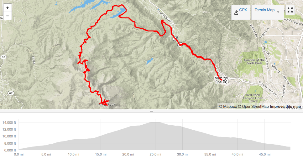
    Distance:               49.7 miles
    Elevation gain:     8,268 ft
    Moving time:        5:44:49

The alarm sounds at 5am.

Who’s idea was this?

On this particular occasion, it was mine.

Of all the awe inspiring, challenging, heart pounding, and oxygen depriving activities we planned for our road trip, I had been looking forward to this ride the most.

I may not be a keen cyclist, but I’ve heard of this mountain. I’ve seen footage of Hill Climbs from years past. I’ve always wanted to visit this mountain. And when I found out it had been paved all the way to the summit, I knew I had to ride it!

After a successful summit of Mt. Evans a few days earlier, we felt more confident but still somewhat nervous about this ride.

Similar to Mt. Evans, today’s weather called for a 10% chance of rain.

At 7:44am, we left the public parking lot in the center of Manitou Springs and began pedaling. To get to the Pikes Peak Highway from Manitou Springs, you have to ride on Hwy 24. This highway is busy, yet biker friendly. There are “Share The Road” signs posted every few miles and most of the car and truck drivers were courteous.

Cars gave us tons of room and trucks switched lanes to pass us. After a 4.5 mile loud but uneventful ride on the highway we turned left toward the Pikes Peak Toll Road.

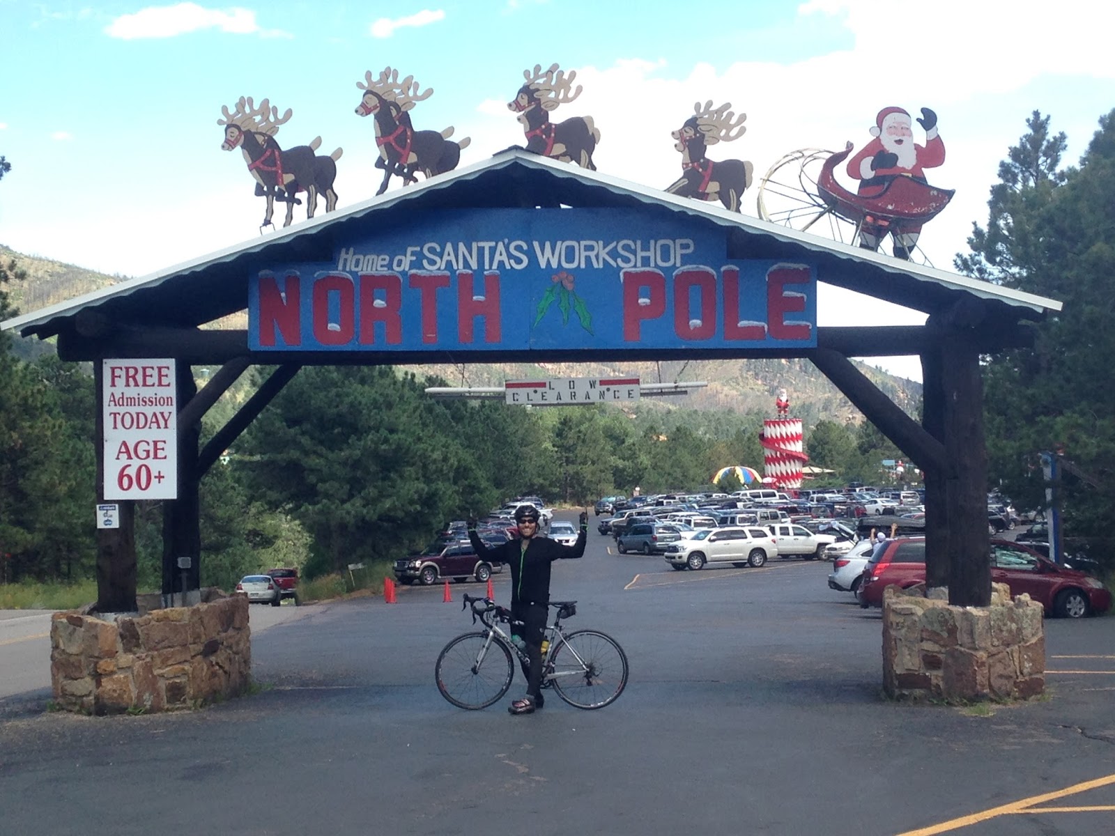
We couldn’t believe the grade of the road. Upwards of 10% for about a mile or so, where it started to level out near Santa’s Workshop at the North Pole.

A few pedal strokes past the Workshop is the Pikes Peak Toll Road entrance gate.

After paying the $12 per person entrance fee , we were on our way!

The first few miles of pavement is like butter. So smooth.

The road was busy, but not overly so.

Tourists from all over the U.S. and around the world zoomed by us – all of them giving us ample room.

Some of them shouted words of encouragement too. This boosted morale – especially when the going got tough later on.

The first couple of miles came easy. The grade wasn’t too bad, the weather was fabulous, the mountain air smelled great and the scenery was splendid.

We were making good time.

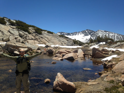
Half way up the Toll Road, we stopped at the Cafe to eat a bar (or two) and top off our bottles. I was loving this ride. Laurie though, was finding it challenging.

But with frequent stops, we kept on climbing.

I have many nicknames for Laurie. On the bike, one of them is The Grinder. Laurie is tenacious. She may not be the fastest rider, but she will get to the finish line. No. Matter. What.

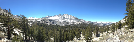
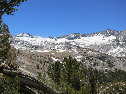
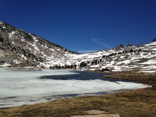
After a few more miles, we were above 11,000ft. Soon after, we were above treeline too.

A long series of switchbacks past treeline lead to spectacular views of the highway and valley below.

What a road!

At the turnout above, we met super friendly motorcycle riders from Maine. They were in Colorado for a wedding, then off to the Sturgis Motorcycle Rally. I love how unique experiences can unite strangers. We were all riding the Pikes Peak Toll Road. We were all on two wheels. They had engines between their legs and we were the engines.

No matter. It was about the experience of the mountain. 

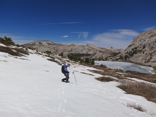
We knew the grade was going to be steeper for the second half of the ride. And coupled with less oxygen, we began to slow.

We knew we could do it.

We knew we could make it to the top.

But we had to set ourselves up for success. By constantly encouraging each other, playing music and taking frequent breaks, we were making great progress.

Scary grey clouds were starting to collect at the summit.

But we were so close.

One final push. That’s all we needed.

After a short break, we pedaled onward.

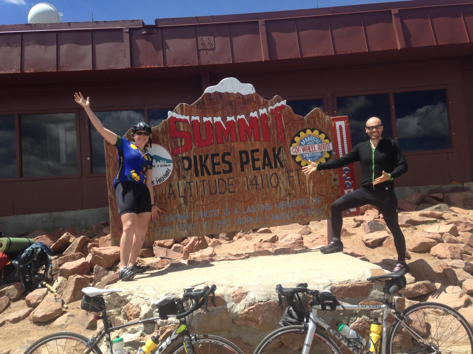
And a half hour later, we made it to the top of Pikes Peak!!

“That was the hardest thing I’ve ever done in my life” Laurie said once we reached the top.

While we both agree she was having an off day, this ain’t no easy bike ride. But it sure is beautiful.

After taking our celebratory pictures, we went inside to sample the highest doughnuts made in the world.

I was expecting big doughnuts of all flavors and theirs couldn’t be more different. Oh these expectations of ours, they can lead to such disappointments.

Honestly though, these doughnuts were so small and oh so bland. Not worth it.

We relaxed at the summit for what seemed to be an hour. We chatted with other riders, ate our bars and enjoyed the views.

When the Pikes Peak Cog Train arrived and hundreds of tourists disembarked, we left.

The downhill was fun but the views were very distracting. My goodness this mountain is pretty.

Going downhill really fast can be problematic because of the views, but slow cars can also hold you up. No matter though. We were really enjoying ourselves.

Just before reaching the Cafe, there is a break check station where cars must stop. We chose to stop too. The ranger thanked us for stopping and went on a rant about cyclists who constantly blaze past the checkpoint.

He promised to put in a good word for cyclists at the next meeting on account of us having played by the rules 🙂

The rest of the downhill run was fun and straightforward. There are a few bumpy sections but nothing too bad.

With two miles left to the entrance gate, we met up once gain with the bikers from Maine. They were enjoying their adventure as much as we were enjoying ours. We said our goodbyes and continued down the mountain.

Once back in Manitou Springs, we changed into our cotton clothes and went in search of lunch before heading home.

Our search didn’t last long. We chose to eat at the restaurant next to the parking lot called Heart of Jerusalem Cafe.

Notice the heart shaped felafels. Nice touch.

Great meal to cap off a great ride.

Tips for biking Pikes Peak:

Skip the ride from Manitou Springs to Cascade (the beginning of Pikes Peak Highway). The highway is loud and cars have a 55mph speed limit. It didn’t add to the scenery of the ride at all. If you want to pad your stats, then ride this portion too, but next time I’d bypass Manitou Springs and start my ride in Cascade, Colorado.

Figures suggest that the average grade of the Pikes Peak Toll Road is 6.5%. But this is misleading. For most of the miles on this road, you’re either going flat (or downhill in a few sections), or steeply uphill. It may average to 6.5% grade, but you won’t be riding that grade much.

Yosemite!! – Part 1 – Vogelsang Loop

In late May we received the tent we hoped would be our home on the PCT next year. We had to make sure we liked this tent so we decided to go to Yosemite National Park and try her out. This trip would also give Laurie an opportunity to finally use her new backpack – the ULA Catalyst she purchased at the PCT kickoff.

We drove to a campground east of Tioga Pass, set up our Tarptent Double Rainbow and sealed its seams.. We had enough day light, it was relatively warm with no wind, so why not? Twenty minutes later the job was done.

  
By 8am the following morning, we were in the car driving to the Tuolumne Meadows Ranger Station. We geared up and hit the trail toward Vogelsang High Sierra Camp, an area of Yosemite neither of us had yet explored. 
Our plan was to hike 15 miles to Merced Lake via the trail to the west that parallels Fletcher Creek and hike out the following day via Vogelsang Pass to the east. 
We shared fond memories of our individual JMT hikes in 2012 as we turned off the John Muir Trail in Lyell Canyon and onto the Rafferty Creek Trail.  
The wide open views got better and better as we hiked the 4.9 miles to the junction that would take us to the still closed Vogelsang High Sierra Camp. 

 
Our early start allowed us to take many breaks, soak our feet in the cool waters and enjoy the views. After the junction to Babcock Lake, we felt the burn in our legs and the heat from the late afternoon sun as we gained elevation. We contemplated ending our day at the crest of the climb partly because we were somewhat tired from two early morning starts we’ve had and partly because of the beautiful views, but we decided to keep going to make the following day easier instead of having to make up the miles from today.
We are glad we kept going because the views got better and better. And soon, Half Dome and Merced Lake came into view. 
Spurred on by the views, we descended toward Merced Lake. At a clearing before the ranger station we decided to take a dip in the river, hoping our sweaty clothes would dry in the sunshine. 
After a refreshing soak, we put on our now dry clothes and proceeded down the trail. At Merced High Sierra Camp we chatted with two men – the only other people there besides us. Soon after, we left the Camp, hiked up to a clearing off trail and found a nice spot to set up our tent for the night. 
We sat on the warm granite rocks after setting up our tent, had dinner and watched the peaks change colors. Soonafter, we retired to our tents and were asleep before the stars came out. Laurie is a champion sleeper and was out like a light. As for me, I tend to sleep very well for the first few hours, but then I wake up and toss and turn for the rest of the night. Tonight though, I hardly slept. 
Because we didn’t want to smell the fumes of the seam sealant, we chose to forgo applying the sealant to our tent floor until after the trip. Our tent was on a slightly angled slope, and let me tell you, I found out really quickly how slippery the tent floor really is. Laurie slid into me for most of the night, pressing my pad and me into the netting all night long.
The morning sun greeted us and promised yet another day of blue skies and warm temperatures. We packed up and were on the trail by 8am. Well, Laurie was anyway. She is quick to pack up get going but I take longer, which irritates her sometimes. A few minutes later, I was ready to leave as well. 
A few miles later we reached a scary log crossing. The log was roughly 12 feet above the raging river below and almost 20 feet long. Laurie went first. She didn’t know it but I was scouting other crossing locations (Laurie is more sure-footed than me and therefore more comfortable with water crossings). 
Before Laurie reached halfway, she stopped, looked back and said, “I can’t do it.” I went out on the log toward her, helped her turn around and get off of the log. This was the first time Laurie had been turned around by a log crossing. After reassuring her that this was indeed a harder-than-your-average log crossing, we found a safer area to cross and were back to gaining elevation in no time. 
The views soon opened up and once again we were stunned by the beauty of this area. So pretty! 

Every step we took, we gained in elevation and got closer and closer to Vogelsang Pass. And the views got better and better. Many people referred to May of 2015 as Maybruary because the Sierras received lots of rain and snow. The snow was still present atop the distant peaks and made hiking hard work. All I wanted to do was stop and soak in the views. 

From Vogelsang Pass, we really got a sense of how much snow lingered from the recent storms. Looking down toward Vogelsang Lake, we knew it would be slow going. But we didn’t think it would be this slow.
We postholed our way down the trail at a steady 1 mph, if that. At times we postholed down to our hip bones! And sinking only to our knees became something to rejoice.

We were very relieved when we made it to Vogelsang Lake. Even the mozzies couldn’t stop us from taking off our wet shoes and sitting on a flat rock for a long lunch break.

After lunch we hiked down to Vogelsang High Sierra Camp on mostly snow free trail. It was here where we began brainstorming about the following day. We had another day in Yosemite and wanted to make the most of our time there. 
Laurie mentioned night hiking to Half Dome since we had a full moon. This was a hard decision for us to make because we had hoped to ride our bikes from Lee Vining to Tioga Pass and beyond. But we didn’t want to deal with all the car, truck and RV traffic. 
So the decision was made. We would hike Half Dome – at night!
I ran down the trail in hopes of getting to the Ranger Station before they closed and securing our permits. But when I got there, they informed me that Half Dome day hike permits were only issued two days in advance. 
I felt dejected. 
Then I asked, “What about overnight permits? Can we get an overnight permit for Half Dome one day in advance?” The ranger – much to my surprise – said yes. 
I greeted Laurie with permits in hand when she made her way to the Ranger Station parking lot. It was now 5pm. At 11pm we would start hiking again!
Read part two here.