After a wonderful week of exploring the French Apls by bike and climbing parts of iconic mountain stages on the Tour de France, Laurie and her good friend Jeanie drove back to Italy to greet Andy in Milan.
Stunning French Alps and the Tour de France
We all shared a room in a descent hotel with a surprisingly delicious breakfast buffet. “I wouldn’t be surprised if that woman made all of this herself” Jeanie remarked as we stood over the array of cakes, muffins and other sweet treats.
We also had artisinal breads and cheeses, deli meats, hard boiled eggs and yogurt with many topping options to choose from.
After breakfast, we left our excess luggage at the hotel and headed for the train station.
Along the way we pulled into a large parking lot, where Laurie tried her hand at driving a stick shift Fiat Cinquecento (500). She regrets never learning when she had the opportunity in her teenage years and was super excited to spend a few minutes learning on a rental car.
Outside the train station we said our goodbyes to Jeanie and set off for our train to Verbier, Switzerland.
The full Haute Route traverses from Chamonix to Zermatt, but because we have limited time on our vacation we chose to start from Verbier to get the most out of our adventure.
We listened to the announcements in Italian, French and English (although neither of us speak the first two languages) which listed our stop – Sion – as what we thought was the 3rd one. As we pulled into what we thought was Sion, we shouldered our packs and disembarked.
We walked down to find a board with connecting train information to determine our next platform.
We couldn’t find any train going to Martigny- our next transfer point. But there were a few heading to Sion…weird.
“Are we sure this is Sion?” Laurie asked as she turned to Andy. Sheepishly Andy replied “possibly not!”
We ran back to our train and re-boarded just before the doors closed.
Whew!
We were relieved but also felt embarrassed and couldn’t help but laugh at our mistake.
The mountain bikers we met earlier (and to whom we had said goodbye to moments earlier) looked at us surprised. “One more stop” we explained as we continued to laugh at ourselves.
Lesson learned – look at the station sign before getting off!
We rode for another 10 minutes through valleys with vineyards oriented in different directions, offering great texture to the hilsides. We correctly disembarked in Sion and transfered to another train that would take us to Martigny. From there we took another train to Le Chable, followed by the gondola to Verbier.
The road to Verbier, as seen from the gondola
In Verbier it was cloudy and cold. Then it started spitting rain. And just as we put our rain jackets on, the clouds parted and we started roasting.
We quickly made a plan, found a bank, withdrew Swiss francs and went to the Coop where we bought dinner.
Walking through the side streets to our hotel
Classic Switzerland
After checking into Hotel Les Touristes – a simple, low key hotel with very nice and hospitable staff, we went to our room and gorged on roast chicken, pesto, salad greens, corn crackers and brie.
We stood in a corner of the room, over a small table and ate like hungry stray dogs. “I haven’t had greens in over a week” Laurie exclaimed with her mouth full of chicken meat wrapped in fresh, delicious salad greens and pesto.
We managed to make a bit of a mess but clean up wasn’t terrible.
After dinner we relaxed a little. But this is when the nerves showed up. Laurie was anxious and felt we had done a poor job of packing because she left her pack cover at the hotel in Milan.
We had also chosen to forgo our down jackets since we never hike in them. And because we will be staying in huts, we didn’t anticipate needing them.
Andy reassured Laurie that everything would be ok. That we have mountain knowledge, are both good decision makers and no matter the conditions we would make the right calls.
Laurie was starting to relax.
Since the wifi connection wasn’t very strong in our room we went downstairs to the dining area and created maps on Gaia GPS for all our hiking days. This really helped Laurie because now we had a plan for each day.
Our route. Each color represents 1 day of hiking
When looking at maps, the multitude of routes makes it overwhelming. The Swiss Topo maps look like a mess, so we were glad we got this done.
The staff told us of a free concert in town (classical music) but it started at 11pm. At 10:15 Andy took a ‘nap’ which lead to a deep sleep. Given his 2 days of travel with minimal sleep he is doing quiet well. Laurie wanted to get the most out of our town day but we chose rest instead.
Tonight we are grateful for wonderful friends and punctual Swiss trains.
We know many of you followed our blog because it was about the PCT. We are grateful we were able to share our experience with so many of you.
This week we are embarking on a different type of hiking adventure – the Haute Route in Switzerland. It is nowhere near as long or varied as the PCT but we hope it will be similarly beautiful and captivating. And we hope to make our journey entertaining to follow.
We plan to blog each day to share the literal highs and lows of hiking this stunning trail with you.
Haute Route map
When we started planning for a trip this summer, we had initially brainstormed a trip to Italy to visit a good friend who was living abroad for a year. We imagined exploring the Italian Dolomites through a series of day hikes and bicycle rides.
But as we researched our options, not surprisingly the appeal of a multi day trek became undeniable.
We both fantasize about sleeping in our tent night after night, witnessing spectacular sunrises and sunsets and living a simple life again. While personal matters keep us from hiking another really long trail, this 120 mile trek seemed feasible and enticing.
However, after a bit of research and a few conversations with friends familiar with these mountains, we learned that ‘wild camping’ (or tent backpacking) in some European countries is illegal (as in Italy) or highly frowned upon (as in Switzerland).
One friend from the PCT who lives in Switzerland referred to tent backpacking as “savage camping” and something they don’t really do in his country.
Andy did find a handful of blogs from people who have successfully tented the Haute Route, but ultimately we decided to embrace the culture and experience the trail the European way.
We also didn’t want to worry about searching for inconspicuous places to camp every night. Instead we can get to the hut, get settled and go explore.
And so it was settled, we chose to stay in cabanes (mountain huts – some with private rooms and others with dormitories).
cabane de prafleuri – one of the huts where we will stay
The planning for this adventure wasn’t as arduous as other thru hikes. The trail is supposed to be very well marked, we can drink directly from streams (no filtration required), eat warm cooked meals for breakfast and dinner and enjoy the luxury of sleeping in a bed after a day’s walk.
From what we have been told, hiking in the Alps is unlike the Sierra in that the trail goes straight up and straight down.
While 8 – 12 mile days don’t feel like a lot after constant 20+ mile days on the PCT, the significant elevation gains and losses of each day will more than make up for the lack of miles.
And so it begins….stay tuned for what we consider a glampacking Swiss adventure.
On the PCT last year in Northern California we walked with views of Mt Shasta for days. We walked north, west and south, usually staring at this magnificent mountain. Initially we looked at it with awe, but as the days wore on and our feet got more sore – these pleasant feelings turned sour. We wanted to be making progress and that meant walking past mountains, not around them. By the end, we were muttering things like “damn Shasta, we can’t get away from you.”
We had pondered taking a side trip to climb Shasta while in the best shape of our lives but ultimately decided against it because the conditions were not favorable.
This past weekend, they were!
So we hatched a plan to climb it. But not just Mt Shasta.
We had also walked by Lassen Peak while on the PCT. This looming beauty is not as tall but similarly stood as a prominent figure on the horizon that can be seen for miles and days. In fact, along the Hat Creek Rim one can see both of these mountains.
And so we left the Bay Area on Friday in search of a grand adventure.
Two mountains, one weekend.
Our adventure began around 11 am when we finished packing our car. Ice axes, crampons, helmets, tent, sleeping bags, food and bicycles. All the important ingredients for a fun weekend.
Shasta would be a lot of effort but was logistically straightforward. The route to Lassen however took more creativity. Due to the large amounts of snow, the road out through the park from the southwest entrance was closed to cars. So we planned to bike up partway and then hike the rest.
We drove through the heat of the day and arrived in the town of Mt Shasta around 4 pm. We got our self-issued wilderness and summit permits at the ranger station in town and headed up the mountain to escape the 100 degree temperatures.
Laurie eating a popsicle at Amiratti’s Market in Castella, CA one year apart.
We left the car at Bunny Flat trailhead and hiked up through the slushy snow toward Horse Camp.
Mt Shasta from Bunny Flat Trailhead
After a short 1.5 mile hike we made camp on the snow. We ate dinner on the benches of the Sierra Club Cabin while staring up at Mt Shasta and chatting with Sharon – the “guardian on duty,” and fellow hikers. Actually Laurie chatted while Andy studied the route.
Our home at Horse Camp
Avalanche Gulch route from Sierra Club Hut
Sleep did not come easily that night as it was still light out at 9 pm but we knew morning would come quickly. We set our alarms for 1:15 am with a goal to be hiking at 2am.
The “beep, beep, beep” of the alarm was a familiar sound. We rubbed sleep out of our eyes as we peeled them open. The world was silent.
Andy was the first out of the tent and stopped in awe. The stars were incredible. The milky way was clearly displayed in the starry sky.
The air was pleasant as we started our 6,000 ft ascent to the top. We crunched on, step by step walking up toward the summit of the mountain that loomed in our distance for many days one year ago.
We walked in silence other than the crunch of our crampons in the snow. It hadn’t frozen the night before so the snow was soft. As we got higher the snow became more firm but never too icy.
We passed a few tents and isolated headlights around 50/50 camp and reached Helen Lake at 4 am. We could see a few headlights behind us and a sea of them ahead of us. It was like a glowing worm making its way up the mountain side.
Daybreak on Shasta
We climbed steadily, falling into rhythm with our breath. Left foot, ice axe, right foot, pole and repeat. Both of us were surprised at how good we felt. Our bodies like to move and once given the opportunity we easily fell into our groove.
Around 5am the sky turned pinkish orange. Mt Shasta cast a huge triangle-like shadow on the valley below.
“Rock. ROCK. ROCK” people echoed as rocks came tumbling down the mountain. Falling rocks are a real danger on this mountain. Thankfully we avoided them all.
We reached Heart Rock and the Red Banks around 6 am. From here the pitch steepened even more. Every 5 steps we stopped to catch our breath. From Horse Camp, it looks like the incline lessens after the Red Banks. Unfortunately this is an illusion.
Nearing Red Banks, still smiling!
“It should be called Red Bluffs!” Andy proclaimed, leaning over his ice axe.
The hill continued on and on.
Eventually the mountain leveled out, but the wind had picked up. It was cold! We chose to take a rest break anyway as there were exposed rocks on which to sit.
Laurie’s tummy wasn’t doing well all morning but the break helped. With our teeth chattering we shouldered our packs and hit the trail once more.
Misery Hill
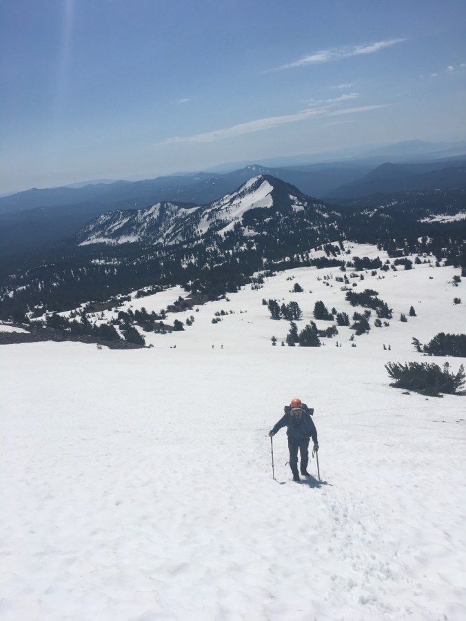
The incline steepened again as we started the final push up Misery Hill. This is a very appropriately named hill. As we crested Misery Hill the summit finally came into view.
Not far to go now
The snow on the summit twinkled in the bright blue sky. It’s so jagged and rocky! We eagerly walked across the plateau and up the final 200 ft to the summit. As we made our way around the backside of Shasta, the aroma of sulphur hit our noses quite intensely. We looked to our left and noticed steam rising above the snow.
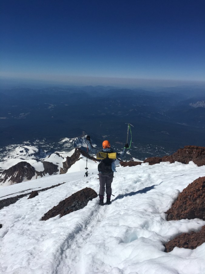
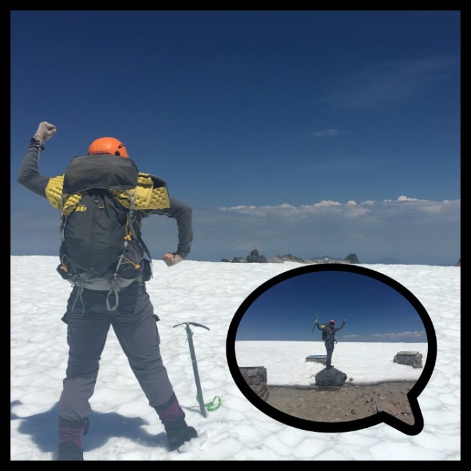
Once at the summit, we joined about 20 other people enjoying a snack and a rest at 14,161 ft. It was 8:15 and we had climbed another 14er!! That feeling of accomplishment never gets old.
Another 14er under our belts!
We took pictures, signed the register and ate lots of food. After 20 minutes or so, we were ready to head down.
And now the fun began – or so we thought. Laurie had climbed Mt Shasta once before and what she remembered most were the glissades. But since it was only 9 am, we had to wait a few hours for the snow to soften before we could descend safely.
Heading down Misery Hill, feelin good
We weren’t about to wait so we gingerly made our way down, continuing to walk with our crampons. On Misery Hill we stopped to take off our crampons and attempt to glissade. Andy put on his rain pants and went first. He went quite fast and a bit out of control.
This terrified Laurie who still has a little PTSD from her uncontrolled glissade on Glen Pass. She took off her rain pants, put her crampons back on and continued to slowly march downhill.
Mt. Shastina from Misery Hill
Around 10 am we came to the Red Banks. Avalanche Gulch lay ahead. The incline was steep and parts were still icy. We walked slowly, with Andy very nervous and taking more time to walk down than up.
Laurie waited patiently below watching other people glissade, trying to determine if the conditions were right to have another go.
Our legs were tired from side stepping and the snow was soft so we unclasped our crampons and went for it…again.
The glissade was the longest either of us had ever done. We descended at least 1000 ft!
However, there were still chunks of ice so we used our ice axes to slow us down. We found ruts in the snow from other hikers and as we got lower and the snow softer, glissading became more enjoyable rather than just bearable. It felt like we were on a water slide of snow.
You want summa this?
It was hot when we reached Helen lake. Lots of hikers were back at their tents and others were cresting the hill about the set up their tents for an attempt at the summit the following day.
We glissaded down to Horse Camp both on our feet and our now frozen bottoms.
Once at Horse Camp we disassembled our tent and packed up in less than 20 minutes. We said goodbye to the lovely Sierra Club host, Sharon, and headed down to our hot car at Bunny Flat.
Laurie with Sierra Club Hut host Sharon
It had been a very long day but Laurie was already fixated on the next adventure – Lassen!
We stopped for a grass-fed burger in Dunsmuir – more cheese than beef but tasty nonetheless – and continued on towards Lassen National Park.
We had originally planned to get a backcountry permit and camp near the base of Lassen Peak but as Andy frequently reminded Laurie, things take longer than we think.
So we found a Forest Service road very near the park entrance and set up our tent in the woods. It was still 80 degrees when we crawled into our tent around 8 pm. The forest was alive with bugs, birds and rays of sunshine. It felt great to be lying horizontal and we both immediately fell asleep.
At 5:45am we woke up naturally. The sweet forest air filled our noses and warmed our hearts with familiarity.
We weren’t sure how sore we would be this morning, but surprisingly both of us felt pretty good, except for the ice burn on Laurie’s left hip and a small abrasion on Andy’s right elbow.
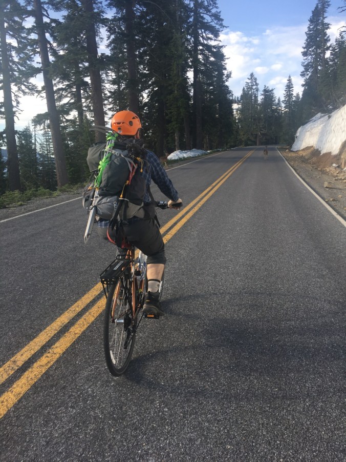
We packed the car and drove to Sulphur Works in Lassen National Park. The road was closed past the parking lot. Laurie loaded her bike with panniers filled with water, bike locks and crampons while Andy rode with his backpack on, and strapped to it our trekking poles and ice axes.
Sulfur Works parking lot, ready to ride, then climb!
We rode up the car-less road, enjoying the cool morning air and admiring the views. At one point, we shared the road with a couple of deer.
Deer Crossing!
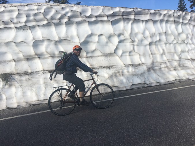
Water gushed down the hillsides and along the road. Snow lined both sides of the road for most of the ride, in some places as high as 10 feet.
walls of snow
Close to Lake Helen, and still a mile from the Lassen Peak trailhead, we came upon lots of heavy machinery and a snowy road. We had reached the end of the exposed pavement. We locked our bikes to one another, strapped on our crampons and set out.
Is it really summer?
The only other people there (on a Sunday) were a couple on AT skis. We felt like we had the park to ourselves. It was fabulous.
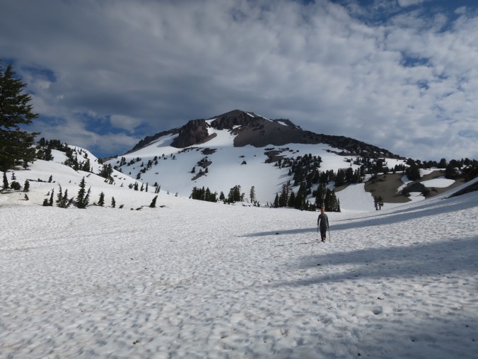
We looked at the map of the summer trail on the Gaia app, compared it to what we were looking at in real time, set a plan and got to it. Unlike Shasta, we wouldn’t have to gain ~6,000 vertical feet to reach Lassen Peak, but that didn’t mean the climb would be easy. The slopes were steep and the snow a combination of ice and slush.
many feet below is the road
can you see the backcountry skiers?
getting closer to the summer trail
After crossing a few steep snowfields Laurie veered left toward the exposed rocks on the ridge and found the summer trail! This was a relief to both of us because the last 1/3rd of the climb looked particularly steep.
We took off our crampons, Andy gave Laurie the backpack to carry and we continued up the trail. “It’s so nice having a trail” Laurie mentioned over and over again with a smile.
Nearing the top of Lassen Peak
We made really good time hiking up the mostly snow free trail. Before we knew it, we were at the summit. We walked onto the snowy plateau and looked through the haze to find Mt Shasta. And there it was, a snowy, prominent triangle 100 miles to the north. It’s hard to describe the feeling but Andy felt accomplished and very nostalgic.
Feeling accomplished!
Can you see Shasta?
It is nice to know that while at the moment we can’t step away for 6 months to hike a long trail, we can still have epic adventures on the weekend.
We returned to work and responsibilities with a little more lightness. Spending time in nature helps us reconnect to one another and our souls. It is a wonderful reminder that Nature is always there when things get tough.
Tonight we are grateful for our strong bodies, good weather and beautiful mountains.